Hi
We’re working on a COVID19 response system and the County Council’s partner orgs have created an arcGIS webapp with a bunch of layers identifying; Points of Interest including pharmacies, hospitals, community groups etc, AND boundary data for the above.
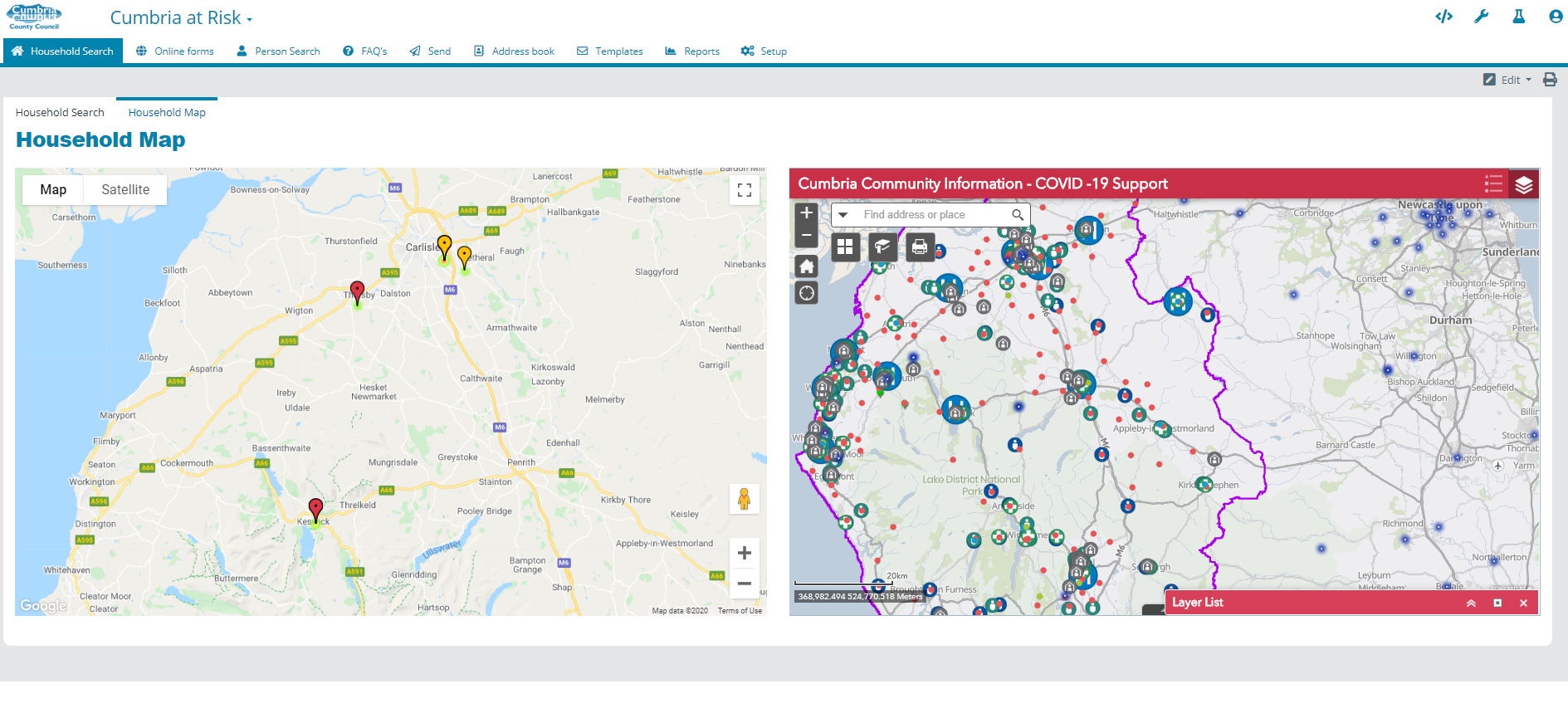
We would like to be able to view our Liberty Create data in the same system (we are holding location data for vulnerable households in Cumbria) For now I have them side by side.
I don’t know GIS but I think I would be able to export from Create / create an API that provides our household data to their system, but I’m reluctant to share all that info about where our vulnerable people live. So the project team are asking if we can feed the GIS layers into Create. Can we? It sounds tricky.
Just a quick update on this.
We’ve decided to go down the route of crating an API so the GIS guys can ingest our data and create suitable mapping layers.
We’re also creating API functions that will allow attributes on the GIS map to post updates in to Create and move processes along or just update the Household data.
Hi Craig - How did you get on with GIS and Liberty Create? I’m looking at making use of GIS data with Create as well, and there doesn’t seem to be a lot of info about!
Thanks Richard - We’re in the early stages of our use of Liberty Create here at Harborough District Council, and we’ve had a project running with our Planning team which included the functionality of drawing polygons on a map. They went with another system in the end, Opus, but the question of what Liberty Create can do with GIS data remains. I’m ‘fact finding’ at the moment, I’d like to find out what the possibilities are and whether anyone has got anything running with regard to Liberty Create and GIS in general.
For instance, I believe we use Uniform as the database for GIS here, so does this mean we would need a custom widget or API to interface with Uniform? We don’t have the skills to write our own, so we’d need Netcall’s assistance.
Councils typically sync their LLPG from Uniform to Create using the Liberty On-Premise Adapter (OPA).
Create has a Google Maps widget which can be used to display singular or multiple addresses and allow for the selection of a single point.
Create in and of itself is not geo-spatially enabled beyond the entry and storing of location points, however we can do some smart things using our code studio environment.
We can identify the nearest properties to an individual point and have been able to identify which area a property belongs to given polygons of each area.
If you would like a call to discuss your ambitions further please reach out to your account manager to arrange a call.
This is also something that we are exploring at Waverley BC. We want to be able to, for example, establish land ownership in order that a process can be fired off in the appropriate direction for a report of fly-tipping, grounds maintenance etc etc. So what we need to do is have a way of keeping up to date polygons from our GIS dataset in create so that we can run an intersection query. It sounds like you have been able to do this, so I would be very keen to find out how it is done.
Unfortunately, waterfall matching a set of co-ordinates to 4 polygons, singularly on insertion, is quite a world away from the real-time matching of a co-ordinate set to many multiple sets of polygons.
I would be very interested to discuss with you where this polygon data currently sits and whether via API or utilising OPA and forming geo-spatial database queries we could help you implement this particular use case.
We do have ambitions to implement geo-spatial features natively in Create but we are not yet there.
Hi Mark,
GIS is an area we’d like to explore a lot more of. Currently we are using API functions we have created in Create for ESRI to consume and also actions in ESRI trigger API calls into Create to update cases.
For our uses we’d like to see nice open standards in the GIS systems so it is easy for Liberty Create to integrate with them. It’s then easy for your GIS officers to maintain your polygons in a corporate GIS system and Liberty Create could easily send coordiates through an API to receive a response from GIS system of which polygon(s) the point is within.
Having said that I don’t think it would be too difficult to build a code studio widget that allows the users to draw a polygon and for create to hold the points in a data object.
Thanks for the input Craig, we had looked at creating a polygon tool, however, without an effective mechanism to search against it, we felt it wasn’t the right time.
As soon as we have support for point and area data types and the means by which to search against them we’ll be sure to revisit this.
Many thanks Craig, Adam, Richard - There’s obviously some demand for an effective polygon widget / functionality in Liberty Create and this has got me wondering about location data and Liberty Create in general - although I realise that this is close to going off-topic. I’m certainly very interested in hearing about progress in this area, as it impacts on much more than Planning-related functionality.
We have previously created ESRI/ArcGIS versions of the Map and Map Input presenters (for displaying or dropping a pin on a single lat/long location) within Code Studio.
Although these won’t help directly with the polygon search ideas discussed, they may be a useful reference for creating other ESRI-based presenters or widgets, as their ArcGIS Javascript API has a lot to offer. They are also a nice alternative to the built-in Google Maps presenters for single locations, if preferred, with the benefit that you could extend them further to offer more features.
For anyone stumbling upon this topic later, the Create 2021.3 release now has a whole set of new GIS features, including support for Polygon data types and searches.
I would love to see the “ESRI/ArcGIS versions of the Map and Map Input presenters (for displaying or dropping a pin on a single Lat/Long location) within Code Studio.”
As using ArcGIS maps directly in Liberty Create is preferable to customising a Google Map presenter and then using ArcGIS Api Calls.
We have various maps where we are asking users to drop a single pin e.g. fly tipping, ground maintenance, this would be fantastic solution, as we could block out or redirect cases appropriately…eg “Not our Land, report to Local authority”.

 - although I realise that this is close to going off-topic. I’m certainly very interested in hearing about progress in this area, as it impacts on much more than Planning-related functionality.